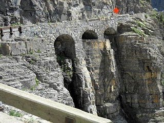
We woke up early to drive Trail Ridge Road without traffic. This road cuts across RMNP and is the highest major highway in North America, climbing to 12,183 feet. It is currently under construction and we were warned that traffic can be backed up 30-60 minutes this summer. Our early start paid off – there were very few cars on the road and we saw some wildlife eating breakfast (including the biggest elk we’ve seen – he was huge and right next to the car!). We made our way along Trail Ridge Road and left the park. We were excited for the day, as we were going through Boulder and Vail (2 places I’ve always wanted to see) and were eventually making our way to see Deven’s longtime friend, Katie, in Aspen. We drove through Boulder and stopped at Costco (had to re-stock the Sprinter with a few goodies), stopped in Vail, stopped at Starbucks (thank you Howard Schultz for putting Starbucks everywhere in Colorado!), and finally made our way to Aspen. Today was a big day for a few reasons. #1 – we passed 3,000 miles for our trip so far. #2 – we finally have music! We went nearly 3,000 miles without music, can you believe that?! We have radio reception, but the music is not exactly what you’d want on a road trip. Deven has a brand new stereo to hook up (one of the many projects she brought to complete on the trip!), but it hasn’t been installed yet. I have music on my computer, but it’s not quite loud enough while we’re driving. So, today at Costco, we bought a portable player for our iPods and we don’t even know what to do with ourselves. From Vail to Aspen I made Deven play Name That Tune, as I scanned the 10,000 songs on my iPod. She knew everything – from Earth, Wind, and Fire to Busta Rhymes…she even got Patsy Cline! That made our drive go quickly and soon we were in Aspen. Deven was excited to be returning after living here 14 years ago. We drove into downtown, walked around, and had a nice meal. #3 – we ate at a real restaurant! We had dinner and margaritas and it really felt like vacation! I loved Aspen – it’s one of my all-time favorites! We made our way out of Aspen to go to Katie and Kipp’s house in nearby Basalt. #4 – interaction with other adults! We visited with Katie, toured her amazing property and beautiful home (surrounded by red cliffs and hillsides on all sides), played with her dogs, and even tried her new slack line. #5 – we also had real showers and were able to sit on the couch and chat and relax. It was a great night and we had so much fun catching up with Katie. We looked at Katie and Kipp’s wedding photos and look forward to meeting him in the future! Thank you Katie for an evening of civilization, your kind hospitality, and a long overdue visit with Deven!
A 28-day road trip and 21 National Parks! After watching National Parks: America's Best Idea (all 6 discs!), reading Fodor's Guide to The National Parks of the West, and using a road atlas to plan an itinerary and route...we are ready for an amazing adventure! Traveling in a self-converted Sprinter, we hope to experience our nation's most beautiful rocks, trees, cliffs, rivers, lakes, plants, mountains, trails, caves, and so much more! Please enjoy reading about our journey…Park Sprinting 2010!
Day 11: RMNP to Aspen
Day 10: Rocky Mountain National Park
We headed into Rocky Mountain National Park early to secure a campsite for the night. We made a quick stop at the nearest Visitor Center (a historical landmark, designed by the protégés of Frank Lloyd Wright) and learned that there were only 7 tent sites available in the park. We quickly made our way to the open campsite and found a great spot. Rocky Mountain National Park is the first park that looks similar to the Northwest – there are trees everywhere and it is very green. Only two differences: true to its name, there are rocks, boulders, etc. everywhere and there are large brown patches scattered throughout the forest due to the infestation of the pine beetle that is killing many of the trees. We settled into our campsite and decided to spend the day out of the car. We rode the bikes to a trailhead and set out on an 8-mile hike. We began by hiking the perimeter of a beautiful subalpine lake (Bear Lake), continued on to Alberta Falls and climbed 1000 feet on a rocky trail over boulders and rivers to Mills Lake. Some quick facts about this place: the chain of the Rocky Mountains is the world’s longest mountain barrier, stretching 2700 miles from Alaska to Mexico. This National Park was established in 1915, contains 72 named peaks above 12,000 feet, and is covered in granite rocks that are up to 1.3 billion years old. This hike was so pretty and we enjoyed the afternoon thunderstorm that rolled through. We had heard this was a daily occurrence and were warned to stay below timberline when the lightning hit. We followed these guidelines, enjoyed the exercise, and eventually made our way to this beautiful lake surrounded by snow-capped mountains. It was obvious we were from a rainy state because nearly everyone else we passed had on raingear and they looked at us like we were crazy in our tank tops and shorts. We stopped to eat a snack at the lake and were sure to hydrate…at nearly 12,000 feet, we were definitely adjusting to the altitude. We made our way back to camp and for the first time made dinner while the sun was still up. After some quinoa and vegetarian hobo stew, I taught Deven how to play cribbage and we went to bed early…worn out from our beautiful, yet tiring hike!
Day 9: South Dakota to Colorado
We were up early in Hot Springs, South Dakota and finally showered! We were off to Jewel Cave (not to be confused with Wind Cave, the National Park we visited yesterday) in northwest South Dakota. This National Monument is buried beneath the Black Hills; within 3.3 square miles, it covers 165+ miles of caves (they just discovered a few more miles last month) and is the second largest in the world, only smaller than Mammoth Cave in Kentucky. The passages are several layers deep and we were able to go about 250 feet below the surface to see some of the amazing crystals this cave is named for. It was so cold down there and even though Deven was afraid of bats, she quickly relaxed when our park ranger told us we were too deep for bats to survive (although this cave is home to 7 different types of bats). After learning a little bit about how the crystals formed and the exploration of this cave, we were back in the car and off on a 350 mile drive. We drove out of South Dakota and back into Wyoming, going hours without seeing anything other than open grasslands. The first town we came to had a sign that said Population 1! I was praying we didn’t have car trouble in this middle-of-nowhere highway and we finally made it to southern Wyoming where we started seeing signs of life again. We were in desperate need of Starbucks because we hadn’t seen one since Idaho more than a week ago! I found 5 Starbucks in Cheyenne thanks to bing.com and we eagerly awaited the lattes that were only about 100 miles away. We drove through downtown Cheyenne (which was very crowded due to a big rodeo that was going on) and stopped at Starbucks. Ahhh….we were rejuvenated and ready for the rest of our drive. We left Wyoming and entered Colorado en route to Rocky Mountain National Park. We made our way through the mountains as the sun was setting and we started realizing it was probably too late to get a site in the park on a Saturday night. We rolled into Estes Park (just east of RMNP) and it was packed! Estes Park is definitely a weekend destination for many people, as the streets were full of people coming and going to dinner, bars, and family-friendly areas. Every sign said NO VACANCY. We were tired after a long day of driving and pulled into a place just outside of the park that said no vacancy. Thankfully, one spot had just opened up and we had a place to sleep for the night. After a long, boring drive we called it a night just about a mile outside of Rocky Mountain National Park.
Day 8: A Day of Sprinting
Today was truly a day of park sprinting – I’m not even sure I can remember the details of all that we’ve done. We left Bear’s Lodge early and passed through more small towns in Wyoming. After looking up the state’s population (a stat I wish our GPS had!), I realized why it feels so different here. The state of Wyoming ranks 50th in population and has significantly less people than the city of Seattle in the entire state. No wonder we still can’t find a Starbucks! We crossed the border into South Dakota and made a quick stop in Sturgis, a quaint little town that is very busy preparing for the 70th annual motorcycle rally that spans the first two weeks of August. Everything in this town seems to cater to motorcyclists, but we cruised the streets in the Sprinter anyway and stopped at Harley-Davidson just to check it out. From there, we went to the Wounded Knee museum. My travel book said, “This modern facility interprets the history of the December 29, 1890 Wounded Knee Massacre through interactive exhibits with historical photos and documents.” So, that influenced our expectations and I was looking forward to seeing a modern tribute to this awful part of our country’s history. You can imagine our surprise when we pulled up to a tiny building that looked like it had just been converted from an Azteca restaurant. There were t-shirts hanging on a metal rack in front of the building, what looked like the start of a tipi in front of the door and it said Wounded Knee Museum. I read the description from the travel book again and we backed out, thinking this must be the cheesy tourist stop. As we were pulling away, I checked the address and we were appalled to realize we were in the correct place. On the inside, it was a little bit modern but the cheaply painted turkey “peace feather” that came with the cost of admission was our first clue that this was not going to be what we’d hoped. We read the typo-ridden displays and learned about the 300 Lakota, mostly women and children, who lost their lives. It was disheartening to learn the details about this day and the events leading up to what was the last major conflict between the U.S. military and the American Indians and the end of life as the American Indians knew it. We returned our turkey feathers and pulled away from “Azteca” feeling disgusted and ready to see something inspiring. Our next stop was Badlands National Park. I’d never heard of this place, but after watching the documentary I really wanted to stop here. As we pulled in, we were commenting on how this is probably called the Badlands because it looks so badass! We stopped to take pictures at the first outlook and it was amazing. I’ve never seen anything like this. As we approached the boardwalk that led into the buttes and spires (I don’t really know what that means, but I can’t really describe this place in my own words!) I was shocked. The sign said – Beware of rattlesnakes on the path. From bears and bison to this crazy, HOT, odd-looking place full of snakes. Get me out of here! As we walked along the boardwalk, we tiptoed down the middle thinking that would keep us the furthest away from the snakes. We weren’t prepared for the enormous grasshopper-like things that were hopping all over the place and landing on our legs and feet. We ran to the end of the boardwalk, took a few pictures, sweat out all the water we’d drank and quickly returned to the car. We were so thankful we didn’t push on to spend the night here last night. I decided that this place is called the Badlands because everyone who visits has a bad time here, but Deven’s theory was a little bit funnier. She thinks parents bring their kids here so they can return home and threaten them when they’re bad by saying, “If you aren’t good, we’re sending you to the Badlands.” That pretty much sums it up. It was a fascinating place to see, but we were over the heat, flying bugs, and snake warnings pretty quickly. Described by Custer (before he marched right through to push the Indians out of the more desirable land) as “hell without fire” it is definitely unlike anyplace I’ve ever seen. The result of 3 million years of erosion and home to many interesting fossils (which we did not stop to see – that’s how miserable it was here!), this crazy place has frequent droughts and a winter that lasts half the year. After a 30-minute sprint through this park, we headed towards Mount Rushmore. We stopped in Interior, South Dakota just 2 miles outside of the Badlands. This place was also strange – the gas station, called Cowboy Corner (which had the pump hanging on a coat hanger), was also the only “restaurant in” town. I think the population was about 12! We drove through the driest land I’d ever seen and we had more bugs splatter on the windshield than any other part of the drive. Deven thinks it’s because they’re so miserable they’re committing suicide just to get out! Soon, we started seeing recognizable landscapes again and we drove through the dark green trees (the appearance from afar is the reason for the nickname the Black Hills, I’ve learned) to Rushmore. We drove through the little town of Keystone, South Dakota – which is basically like the Vegas for families heading to Rushmore. No, more like the Reno for families heading to Rushmore. It was a small town full of tourists! We stopped at Rushmore, toured the museum, and took some pictures. It was now about 2:00 and we realized we hadn’t eaten anything all day. We’d been park sprinting and lost track of time. So, we sat on the side of the road with the Sprinter door open eating yesterday’s grilled potatoes and corn. Then, we sprinted to our next place – the Crazy Horse Monument. This place is amazing and I hope I can return to see the ambitious plans completed someday. We learned a lot about the development of this project, the family’s determination to finish their father’s work, and Crazy Horse’s quote that drives it all: “My land is where my people are buried.” We sprinted out of the there and tried to make it to our next stop, Wind Cave National Park. Their cave tours had ended, but we toured the Visitor’s Center and made a plan to return in the morning. On the way to our campsite, we called the Mammoth Site and realized their last tour was in 20 minutes. So, we hurried through Hot Springs, South Dakota and literally ran to make the final tour. We learned that in the 70s a developer and his crew hit a bone while bulldozing. He called the local university, who called in experts and they determined these were mammoth bones. The developer sold the property back to the city for the exact price he paid and the non-profit organization that took over the dig decided to leave the bones as they were originally found for the public to view them in-situ. We were so relieved – finally some history of Americans who did the respectable thing! After this, we were so exhausted. We made our way to our nearby campsite for the night, made dinner, and ended our long day. We didn’t even shower and that tells you how tired we were because this was the first site with a shower in 5 days…gross! But, all 3 of us (Deven, myself and the Sprinter) survived hundreds of miles between Sturgis, Wounded Knee, The Badlands, Mount Rushmore, Crazy Horse, Wind Cave, and the Mammoth site in one day. We’re 2500 miles in, learning a lot, having fun, and still smiling!
Day 7: Little Bighorn Battlefield and Devil's Tower (a.k.a. Bear's Lodge)
We were up early and out of camp by 6:00 a.m. I’ll miss Slough Creek – it was a small, quiet, scenic place to stay for 3 nights. We headed out with uncertain plans for the day. Our ultimate destination was South Dakota (Badlands National Park, Mount Rushmore, Crazy Horse, etc.), but we were debating about going through Crow Nation or stopping at Devil’s Tower on our way. We decided to drive and figure it out as we went, as they were both about 300 miles away. We drove through Beartooth Pass, the only exit out of the northeast corner of Yellowstone; the views were stunning. We drove up to nearly 12,000 feet (a stat displayed on the GPS – something I’ve become even more obsessed with lately!) on a narrow road that weaved in and out of giant glacial boulders, creeks, and lakes. The Sprinter handled it beautifully and Deven imagined how fun this drive would be in her father’s racecar. I verified that she was going the speed limit (on the GPS – another favorite stat!) and reminded her that we are in a 6-wheeler that is nearly 25 feet long. After our descent, we went through a lot of little towns scattered throughout Montana and Wyoming. We often went several miles without seeing an exit or sign of any activity. There were a lot of non-descript little structures in the middle of nowhere and we’re pretty certain there’s some secret government projects going on around here! We made our way out of Wyoming, and looped back into southern Montana, stopping at the Little Bighorn Battlefield. This National Monument, which consists of a National Cemetery, the battlefield itself, and a small museum, memorializes one of the last armed efforts of five Plains Indian tribes to preserve their way of life. The battle lasted 2 days in June of 1876 and 260+ American soldiers were killed and less than 100 American Indians died (mostly Lakota and Cheyenne). We toured through the museum and stood on the spot where Custer’s Last Stand took place. This memorial was a little frustrating because it’s presented mostly from the American soldier’s point of view. There was one part designed by members of the Lakota, Cheyenne, and other tribes, which paid tribute to the fallen American Indians. There were very poignant quotes from tribal members past and present along with symbolic structures and art within the memorial. Also in tribute to the American Indian perspective, the name was recently changed from Custer’s Battlefield to Little Bighorn Battlefield (named after the adjacent river, Little Bighorn). From there, we drove back into Wyoming and made quick stops in both Sheridan and Gilette – two places I cannot even compare to any town I know near Seattle. They were both so small (even though they’re two of the bigger cities in the state), full of cowboys, and seemed like we went back in time about 25 years. There was a little bit of activity in Gilette, as they were in the middle of the National Rodeo High School Championships. I made Deven wear her cowboy hat into the grocery store (even though she was wearing workout shorts and tennis shoes and carrying my little coach purse)…needless to say, she was getting some very interesting looks and I couldn’t buy a thing because I was laughing so hard. We were back on the road and decided to stop at Devil’s Tower, our nation’s first national monument, located in the northeast corner of Wyoming. After driving about 460 miles for the day, we found a campsite in the park, and headed up the hill to tour the monument. Even if you know this structure from the movie Close Encounters of the Third Kind, it would still surprise you to see it jutting up in what seems like the middle of nowhere. The geological story is basically another case of erosion; however, the American Indians have many different legends that tell the story of what most tribes call Bear’s Lodge – a place they hold very sacred and still come to pray near. It is a place of controversy for the American Indians because the common name has such negative connotations and nearly 5,000 rock climbers travel here each year from around the world to ascend their sacred place. We learned a little bit about the legends of what I insist on calling Bear’s Lodge, walked the 1.5-mile trail around the base and attended a ranger-led information session around the campfire later that night. Tomorrow, we’re heading into South Dakota and I’m so excited to see Mount Rushmore and Crazy Horse.
Day 6: Grand Teton & Jackson Hole
We were up early to make our way to Grand Teton National Park for the day. There were a few things we still wanted to see in Yellowstone and we were hoping to beat the rush of the crowds. Along our early morning drive, we saw a black bear near the road, deer, and yellow-bellied marmots. We were also very lucky to see a Mama Grizzly and her two cubs. We watched through the binoculars as the cubs frolicked in the grass as their mom strolled nearby. The one thing I really wanted to see was a herd of bison and Deven really wanted to see baby bison…and today, we finally saw that! Hayden Valley (which we now call Jackpot Valley, as it is the jackpot for wildlife viewing!) had herds and herds of bison. They were lying down, playing, crossing the road, butting heads, rolling in the dirt – you name it, we saw it! After slowly making our way through Jackpot Valley, we stopped at a few waterfalls – Tower Fall, and the Upper and Lower Falls of the Grand Canyon of Yellowstone. We stopped at a few different lookout spots along the Grand Canyon of Yellowstone. This picture of the Lower Falls was taken at a beautiful spot called Artist Point. A little less than 10 miles south of Yellowstone is the entrance to Grand Teton National Park. This park is much smaller than Yellowstone, covering about 300,000 acres. As we approached the park, I read about how stunning the sight of the Teton Range is due to the fact that there are no foothills impeding its 7,000 foot ascent. However, upon our arrival, it was raining so hard and the clouds were so thick we could hardly see anything. We stopped and took pictures anyway, toured an Indian Arts museum, looked around an amazing brand new, LEED-certified visitor center and eventually made our way across the park to Jackson, Wyoming. I always thought Jackson Hole was the city, but I learned that Jackson Hole is actually the valley and Jackson is the city…even though we refer to the city as Jackson Hole and there are many signs throughout the small, but bustling town referring to itself as Jackson Hole. Some interesting geological facts about this area: due to an active fault, Jackson Hole has been sinking for 9 million years, while the Tetons have been slowly rising; also, atop Mount Moran (12,605 feet – one of the taller of the range) sits a patch of sandstone that matches another layer of sandstone about 24,000 feet beneath the surface of the valley. It’s crazy to think about how fault lines, volcanoes, erosion, etc. have created some of the most beautiful sights I’ve ever seen. Heading towards Jackson, we were scanning the valleys for moose and elk. All literature refers to the fact that tourists will see an abundance of both; however, we saw neither. Maybe because of the heavy rains and thunder – who knows, but we saw nothing. After eating lunch in Jackson Hole, taking pictures with the famed antler arches, and walking the streets, we headed back through the park – certain we would see some wildlife now that the rain had passed. We did see wildlife – one little coyote right by the road. I felt ripped off! No moose? No elk? We eagerly awaited our return trip through Jackpot Valley so we could feed our newest addiction of seeing animals in the wild. The drive back through Yellowstone and along Yellowstone Lake was so pretty – the sun had been shining there all day. Jackpot Valley delivered and we photographed more herds of bison. It’s such an amazing sight and every time we spotted another herd, we pulled over and took pictures like we’d never seen them before. We saw another grizzly wandering near our campsite and only minutes after pulling into Slough Creek for the night, a thunderstorm passed through camp with heavy rains and lightning that lit up the sky – it was amazing! At this point, we were not leaving the Sprinter, so we called it a night. It was another late night and a long day of driving, but we are determined to get an early start tomorrow.
Day 5: Slough Creek
Hooray – we slept in until 7:30! The next site over, which is closer to the creek, opened and we upgraded for our second night in Yellowstone. I am currently sitting creekside (my view is the picture of the water, which I just took!), watching a group of fly fishermen, with my feet resting on a log. Ahhhh! I’m starting to relax. No organizing in the Sprinter, no traffic jams, no crowds of tourists, no scrambling for our next campsite. Blueberry pancakes for breakfast and no plans for the day – life is good. I sat by the water and read background info on upcoming parks, while Deven constructed bug screens to cover the windows at night. After a few hours of relaxing, Deven came up with a master plan for rearranging the Sprinter. We moved some of our “furniture” (bins, cooler, refrigerator, etc.) around, Deven built in a little counter, and I (of course) organized the contents of a few messy bins. I think this might be the final rearranging – everything has a convenient, secure place…for real this time! We were hoping to stay out of the car for the day so we headed out on the bikes, hoping to ride to a trailhead not too far down the dirt road. After riding down the road for a few minutes, we both started thinking this wasn’t a great idea. We had seen bears in this area several times and after playing the not-so-fun game of coming up with an exit strategy in case a 400 – 800 pound grizzly came at us running 30-40 mph from different directions, we decided to cut our ride short. As Deven put it, “a bicyclist in bear country is pretty much fast food!” On our ride back, Deven spotted a fire and called it into the Ranger Station. The wind was starting to pick up and the flames were visible from our campsite, but the helicopters came within minutes. We watched as the helicopter made several trips to the nearby lake to dip the bucket in and spray it on the fire. Soon, a ranger came around and said the fire was contained and that we weren’t in any danger. After earning her Smokey the Bear patch for the day, Deven went back to building things in the Sprinter, I sat with a glass of wine by the water and read. We made dinner, sat by the campfire, and called it a night.
Day 4: Yellowstone
We were up early to explore Yellowstone. We left the cabin to arrive at Slough Creek campground first thing in the morning. Along the way, we saw two bison right in the middle of the road, a baby fox playing in the meadow, and a grizzly wandering through the trees. Luckily, we found a campsite. Deven was being cautious driving up the 2 mile dirt road to the campground and I’d been urging her to speed up so the few cars behind us wouldn’t pass us and beat us to a spot. Thankfully, she refused because a nice woman pulled us aside as we were making multiple laps through the 27-site campground and said, “We’re leaving do you want our spot?...we picked you because you were driving slowly and courteously.” It was hilarious and Deven’s been reminding me of it ever since! Shortly after we arrived there was a lot of activity in the camp – a Grizzly just on the other side of the dirt road. A few ranger trucks pulled in and they were doing everything to get the bear to leave camp: yelling, clapping, even shooting to scare it away. The bear finally climbed up the hill behind our campground and went away (shown in the picture, taken from our campsite). When the excitement calmed down, we headed out for the day. A little information about our nation’s first national park: it was established in 1872 by President Grant; it has the world’s greatest concentration of geysers, mud pots, fumaroles, and hot springs; the largest number of free-roaming wildlife in the lower 48 live here, including bison, grizzlies, and gray wolves; at 2.2 million acres, it has more land than Rhode Island and Delaware combined. The main road in the park is the 142-mile Grand Loop Road (in the shape of a figure eight), along which you can see most of the major scenic attractions. During our drive we saw beautiful wildflowers, rolling hills, vast meadows, picturesque mountains, and a lot of wildlife. Elk, black bears, deer, and bison. The bison were all over the place (usually males traveling solo right up the middle of the road!). While making our way to Old Faithful, we stopped at many places along the way. At the Canyon Village Visitor’s Center, we learned about the volcanic activity that made Yellowstone what it is today. We learned about the volcanic eruptions 2 million years ago, 1.3 million years ago, and 640, 000 years ago. The last eruption spewed out nearly 240 cubic miles of debris, causing the central portion of the park to collapse and form the basin it is today. The magmatic heat that caused those eruptions is the reason for the park’s geysers, hot springs, fumaroles, and mudpots. The different cooling patterns of the lava are the reason behind the geological diversity you see here today. We’ve learned so much – can you tell? Although I’d love to go back and teach my 1st graders all about geysers and hot springs, I’m settling for simplistic children’s books all about animals! After brain overload about what created this beautiful park, we stopped for ice cream and headed towards Old Faithful. En route to the famous geyser, we saw a large crowd of cars pulled over and several people along a riverbank near a grazing bison. We pulled to the side of the road and walked to the riverbank to get a close-up look. He was just across the narrow river and soon there was a ranger behind us [far behind us – like 100 yards] warning the crowd, “You are dangerously close right now and if he decides to charge, you’re in trouble.” She reminded us that we shouldn’t be any closer than she was and we all immediately back away. Thankfully, he didn’t charge – but we did get some good pictures! Upon arriving at Old Faithful, we missed the eruption by minutes and had 70 – 110 minutes (faithfully…making it the park’s most predictable geyser; however, it is not the largest nor the most regular) to wait for the next one. We explored the Old Faithful Inn (a Historical Landmark, built in 1903) and waited patiently. Within it’s predictable window, the geyser gushed water about 180 feet into the air. It’s an amazing sight, especially now that I’ve learned what’s happening underground; however, the experience detracted from the natural spectacle. There were rows and rows of benches and hundreds of tourists - the kind of people I’ve waited in line behind so many times at Disneyland…you know, the ones who make the long line not worth the wait! After the eruption, a dad turned to his little girl and said, “So, was it everything you expected?” Her reply, “Not really.” I laughed out loud and Deven turned to me and said, “I agree!” Along the 77-mile drive back to Slough Creek, we saw more interesting geology of the park, elk, and more bison in the middle of the road. We began to re-evaluate our plans for tomorrow because at this point, we were so worn out that we were bored and a little irritated with national icons (Old Faithful) and wildlife sightings. We thought maybe we should take a day out of the car to enjoy nature and avoid rushing around to see all the sights. I said, “At this point, I’m only going to be surprised and excited if we see a T-Rex walking down the road!” Isn’t that disgusting? Only one full day in the park and seeing bison stop traffic has become boring to us. Tomorrow, we’ll be slowing down the pace to recuperate so that we can fully enjoy our surroundings!
Day 3: Great Falls, Montana to Yellowstone
We woke up and continued taking advantage of our luxuries by washing clothes, showering and researching on the internet. We quickly stopped at Jo-Anns for some necessities (a few hanging organizers and velcro for bug netting on the windows at night), washed off the coated bugs on the window, and we were on the road again. The drive was very pretty and so hot! We stopped in Helena, Montana – the state’s capital and a funny little town. The town was small, but managed to have enough space for every fast food place you’ve ever heard of (except no Starbucks in sight…the one thing we desperately needed). We saw some interesting things here: deer eating grass within 5 feet of downtown’s busiest road, a tractor driving with traffic, and a young girl with a swastika tattoo! We grabbed a few groceries and continued on our way. The scenery between Helena and Yellowstone was amazing. Rolling hills and wheat fields full of round bales. We stopped to refuel in Gardiner (a quaint, busy town just outside of the Northern entrance to Yellowstone) and crossed our fingers about securing a campsite in the park for the night. We stopped for pictures at the entrance, a place I was excited to see after learning about some of the history behind it from my new favorite documentary, The National Parks: America’s Best Idea. We intended to stay at the first campsite inside the park, but it was full. Luckily, we were able to get a little rustic cabin just inside the park at the historic Mammoth Hot Springs Lodge. We went for a short bike ride to walk the boardwalks of Mammoth Hot Springs Terraces, where we braved a thunder and rainstorm. In the pictures are a few of the multicolor travertine terraces, formed by slowly escaping hot mineral water. That’s all for today – another long day in the car and anticipating about 5 hours of sleep before our early start to hopefully secure a campsite at what is called the best campground in Yellowstone!
Day 2: Glacier National Park (Going-to-the-Sun Road)
I woke up early freaked out by a bright light, certain that someone was shining a flashlight into the Sprinter! I was pleasantly surprised to realize it was just the sun telling me to rise and shine and see Glacier National Park. The river was audibly rushing nearby and an obnoxious animal (maybe a bird, but it sounded more like a baboon from the primate house!) ensured that I was not going back to sleep. It was 5 a.m. and I was definitely ready to start my day. If I were a true adventurer, I probably would’ve woken Deven up and headed out to see the sights. Instead, staying true to myself, I began to organize! Living in the Sprinter reminds me of college in that I’m thoroughly enjoying the challenge of finding creative ways to make the most of limited shared space! Once Deven woke up, she temporarily caught my organizing disease and got to work. Because we had such a rushed start, the Sprinter was overflowing with stuff haphazardly shoved into any bin or crevice we could find. Deven organized the “trunk” of the car (camping gear, bikes, scooter, tools, etc.), while I spent the morning organizing the living space. It’s amazing what a few bins from Target can do. Some of the areas and “rooms” [bins] of our living space are: campsite maintenance, kitchen sink, bathroom, office, first aid, games, and my favorite – freshen up J (containing hand wipes, hand sanitizer, mouth wash, gum, tissue, etc.). I reminded Deven that anything could be organized with a few zip loc bags and she taught me that anything can go anywhere as long as you have bungee cords to secure it down. NOW, I am ready to start the trip. Everything has a home that makes sense and we can find what we’re looking for when we need it. This might not seem important, but our little organizing party was very helpful and extremely necessary! Finally, we headed out for the day’s adventure. A few facts about Glacier National Park: the park covers 1.2 million acres (1, 563 square miles), has 37 named glaciers, 200 lakes, and 1000 miles of streams. Our first stop was Lake McDonald (a 10-mile-long lake) and then we headed up Going-to-the-Sun Road, a 50-mile highway (the only American roadway designated both a National Historic Landmark and a National Civil Engineering Landmark) that crosses the crest of the Continental Divide and climbs up to 6,600 feet. The vehicle length limit for this road is 21 ft, but we decided to go anyway (the Sprinter is about 22.5). We quickly realized the purpose of the vehicle dimension restrictions; we had to pull in our mirrors for most of the ride to avoid hitting both the side of the mountain and oncoming traffic. The scenery was amazing and Deven’s extensive knowledge and commentary of the masonry work along the way made me appreciate the drive even more. Climbing the mountain in the Sprinter made for an enjoyable, yet anxious ride – I was definitely sitting higher than the practically non-existent “wall” that overlooked meandering rivers and hillsides thousands of feet below. We stopped at several turnouts to admire the picturesque views, take pictures of the waterfalls, and get up close with wildlife. We saw deer, several mountain goats (particularly one funny old guy who insisted on standing in the middle of both lanes, bringing traffic from both directions to a complete stop for several minutes), and big horn sheep. The big horn sheep were my favorite – they’re crazy to see up close in the wild and it’s bizarre to see how their horns seem to meld into their face. After taking a few hours to drive this beautiful highway, we looked for a campground for the night. Everything in the park was booked so we headed out of the park to a nearby National Forest on the Blackfeet Indian Reservation. No luck there (full!), so we drove as far as we could manage and spent the night at the only campground in sight: KOA in Great Falls, Montana. This place was crazy – like Disneyland for the quintessential American family on a camping/road trip! It was a perfect place to sleep and allowed us to get a head start on our next day, but I never imagined this trip would include staying at a campground with volleyball and basketball courts, swings, playgrounds, and a water park with a little water slide! We tried to take advantage of some of the amenities (it hardly felt like camping) and we played on the swings and washed our dishes. After a long day, we called it a night – eagerly anticipating the next day’s drive to Yellowstone – our nation’s first national park!
Day 1: Seattle to Glacier National Park
We are 268 miles into ParkSprinting 2010 and I think I’m finally starting to relax! I can already tell this is definitely going to be an adventure to remember! After a hectic 24 hours, we are both settling in. The Sprinter is not as organized as I would like, but we’ll get there. We left 3 hours later than planned, had a detour to install the inverter (thank you for the last minute help Charlie!), but it was worth it. Deven and I are both well-rested, the refrigerator is up and running and we’re still going to make it to Glacier National Park, Montana well before sunset. There is no better way to convey the differences in our priorities than by describing how we’re currently passing the time: Deven is eager to discuss and learn about the sights we’ll see at Glacier while admiring the scenic fields and weathered barns along the way as I make a very precise mental plan for how to best organize the overwhelming amount of camping gear, toiletries, clothes, recreational equipment, and miscellaneous “must-haves” we both decided to throw in at the last minute! In the meantime, I’m obsessing over the GPS device (thanks for the loan TParks and Scotty!) and we’re both thankful that I finally figured out how to turn the lady’s voice off. Still smiling, still getting along, and still excited! …493 miles in and we’re about 1½ hours from GNP! Currently on a dirt road going 32 mph (as per our GPS device)…at this rate, it’s going to be awhile. It seems like our trip has yet to really start. Had to stop in Bend, WA to get the inverter running, then to Subway for breakfast/lunch. From there, we drove until just past Spokane where we stopped at Verizon to hook up our internet (struck out, sold out of the connection we needed), then a few miles down the road at Post Falls, Idaho to fuel ourselves at Starbucks and visit another Verizon. We were on the road again, past beautiful Coeur d’Alene Lake. I took a 15 minute snooze (a record for me, usually I sleep for my entire ride as a passenger) and have been wide awake since! Had a little fuel scare/friendly reminder when the low fuel light came on and the GPS said the next gas station was 67 miles away! Thankfully, I had incorrectly programmed the GPS and within 7 miles (in Hot Springs, Montana), we vowed to re-fuel whenever we hit ½ a tank. Montana is very pretty and I’m finally becoming more excited about the scenery than organizing! We have definitely seen some things you don’t see in Seattle; there were portable stop lights (I don’t get it…one day it’s there, one day it’s not?), signs that differentiate daytime speed from nighttime speed, and gun racks next to the candy aisle in the gas station! There were also several street signs that made us laugh: Beware: Big Horn Sheep Crossing; Drivin’ With Bears: Your Car Is Your Cage (one of those up-close experiences where you drive through and bears come up to the car) and in the town of Hungry Horse, Montana a hand-painted billboard that said Cherries, Huckleberries, and Elk Jerky. We pulled into the park around 9:00 and, as expected, all camp sites were full. My Uncle Donny told me to pull over whenever anyone else was pulled over because it usually means they’re looking at something interesting. Thanks for the hint, because it helped us catch a glimpse of brown bear standing about 20 feet from the road. After he ran away, we headed up the road in awe of the amazing mountains to the east. After about 15 miles of seeing nothing but trees and mountains in the distance, we came to a dirt road and decided to take our chances. On a tip from a camp site host, we spent the night at a primitive camp site (I’m learning that means no amenities). We were 50 yards from a swiftly flowing river and were one of 3 campers in the area. It was amazing. To end our first day, we quickly doused ourselves in bug spray, had a late dinner, watched an elk pace back and forth around our camp site! Finally to bed at 1 a.m. ready to begin our National Park adventure!