


Coming soon: favorites and least favorites of our trip...


It’s our last day and we’re both so sad that it’s coming to an end. In an effort to savor every moment, we woke up early to make a yummy breakfast before heading out for the day. We drove to the valley and were early enough to avoid the crowds. We rode our bikes a few miles up to Mirror Lake. At this point in the summer, there isn’t much of a lake, but Half Dome towers above this area and there are many trails to explore. We headed off on the trail hoping to make our way to a nearby creek, until we were kindly stopped by some fellow hikers who noticed a mama black bear and her cub up the path. We watched from afar (very far!) as the mama and her cub walked back into the woods. At this point, we decided to turn around and hike back to the bike path. We then rode our bikes a few more miles to Mist Trail, the trailhead for many popular hikes. We envied those heading up to the top of Half Dome, a 16-mile hike, whose last 400 feet up must be ascended while holding a steel cable to assist with the steep climb. We’d had enough of the chain-holding, nail-biting hikes for one trip and decided to save that for next time (actually, we would’ve loved to do it, but being pressed for time we had already planned to stick to the shorter hikes). Instead, we set out for the top of Vernal Falls. This trail was insanely crowded and very steep. It was a paved path and didn’t feel as serene as our other hikes, but after climbing about a mile, we were rewarded with the spectacular sight of the falls and the meandering river that follows. We pushed up the last 1.5 miles that was mostly uneven, granite stairs. This was like the stairmaster from hell and it felt like it was never going to end. Eventually, we were at the top and enjoyed the calm, flowing waters with about 300 strangers. This hike was actually very enjoyable, but we both agreed that it would’ve been much more peaceful had we set out first thing in the morning to avoid the crowds. We were able to find a peaceful rock along the water and had a snack while watching the rainbow trout swim by. We headed back down the stairmaster and kept saying to each other that this was the perfect hike (besides the crowd) to end our trip on. We rode around the valley, toured the museum, and headed back to camp to enjoy our last evening. We made our best meal of the trip, had some wine, read our books, and played some more Connect 4 before having s’mores for dessert. It was a perfect ending to an indescribable journey!
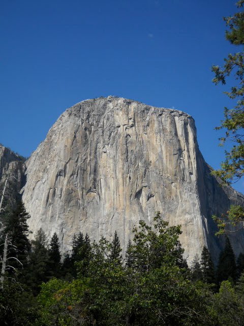


In order to get a campsite inside of Yosemite, we got an early start. We made our way through Mariposa Grove to look at some of the giant sequoias that are hundreds of years old. This didn’t exactly make up for our decision to skip Sequoia National Park, but we were happy to see some of these gigantic trees up close. From here we drove to Glacier Point, an overlook that is about 15 miles out of the way, but well worth the drive. We looked across the valley at Half Dome (a granite dome that rises 4.700 feet above the valley floor) and had clear views of several falls that pour into the Merced River. We then made our way down to Yosemite Valley, an amazingly beautiful place with breathtaking scenery…if it weren’t for the crowded streets and overflowing tourists. The valley was ridiculously crowded, so we decided to skip the sightseeing at this peak time of day and head to a campground a few miles away. We were lucky enough to get one of the last remaining sites and we set up camp in our surprisingly peaceful site near a meadow on the outer loop of a very crowded campground. We were on high alert because we were told at check-in that there is a very active black bear in camp– day and night. We relaxed, read a little, played some Connect 4, and then headed back into the valley for the evening. We took a short hike to Bridalveil Falls. I’m not sure why, but water falling over a cliff is so beautiful to me. We then stood under El Capitan and enjoyed the peace of being away from the crowds. El Cap rises nearly 3,600 feet (more than 350 stories!) above the valley and is the largest exposed-granite monolith in the world. The granite in this park is unbelievable. It’s nice to hear Deven’s perspective having worked with stone for so many years – it really makes me appreciate the beauty of these mammoth glacial-formations. After seeing El Capitan, we strolled along the path to see Yosemite Falls. Even though it is not nearly as powerful as the spring snow melt, it is still a beautiful sight. Yosemite Falls is actually three falls that together constitute the highest falls in North America, and the fifth highest in the world (twice as high as Niagra Falls). After playing on the boulders around the base of the falls, we made it to the theater just in time for our evening event. We attended a one-man show about the life of John Muir, focusing on his fight to prevent a dam in the Hetch Hetchy Valley. The star and writer of the show has been doing this performance for 28 seasons and I immediately recognized his voice as that of John Muir in the Ken Burns documentary. We learned a lot about the life of John Muir and the implications of damming Hetch Hetchy: it erased a beautiful valley, but has provided water to San Francisco’s 2.4 million residents since 1913 and it is considered a major catalyst for the environmentalist movement. After the show, we made our way back to camp. To be on the safe side, we put our food in the bear locker and slept with the bear spray close by!
It was back to park sprinting after breakfast with Beth in Manhattan Beach. We had a 5-hour drive to Yosemite and eased our way back into sprinter mode after the luxury of Southern California. Thank you Beth for letting us stay at your beautiful home. I appreciate your hospitality, the free use of your laundry and shower facilities (this has become quite a treat for us!) and for the many laughs – it was so great to see you! Upon arriving at Yosemite, all sites were full (the story of our lives when we get a late start!), but we pulled up to the Summerdale state park campground right outside the Yosemite gates just in time to secure the very last spot (fortunately, this has also been the story of our lives on this trip!). We decided to forego racing into the park to see the sites and settled in for an evening of dinner and a Connect 4 Pop-Out tournament.
We woke up at 4 a.m. to make the 4.5-hour drive to Los Angeles in time to meet my dear friend Christie for breakfast. Christie, her husband Monte, and her 2-year-old daughter met us for breakfast and we had a wonderful time eating delicious food and catching up. Thank you to Christie and her family for taking time to meet us – especially during this busy time as she prepares for the arrival of triplets in about 7 weeks. From here we headed to my former hometown of Manhattan Beach to stay with another great friend, Beth. We visited, relaxed in the sun, and headed out to the afternoon wedding of yet another great friend, Emily. Deven ran some errands while I spent the afternoon at Emily’s beautiful wedding. At the reception, I visited with my former co-workers, had wine and mojitos on a hotel rooftop in Marina del Rey, and danced the night away. Leave it to the Catholic School teachers to keep the party going until the very end. True to my former days in L.A., we headed to In-N-Out to finish our night. Our plan was to leave Sunday morning, but we decided to relax and enjoy another day in the sun. On Sunday, I attended Mass at my former church and had breakfast with some other dear friends while Deven went for a run on The Strand and relaxed at the beach. I had so much fun and even though it was too short of a visit – it was great to be back in the South Bay.


We were up early for a good breakfast before our hike. We were both a little nervous as this hike has a reputation for its steep cliffs and 7 hikers have lost their lives on those cliffs. We hopped on the early shuttle, fully geared up with water and trail mix. Almost everyone on our shuttle was heading up to Angel’s Landing and we started getting even more nervous hearing everyone talk about conquering this trail. As we headed out on the trail, we were both very thankful for our early start, as the large mountain was blocking the morning sun from hitting the trail. We hiked the first few hundred feet in the shade and when we started reaching some of the first cliffs (these weren’t even the scary parts; the trail was wide, it just had steep cliffs on one side), we were both wondering if we could actually complete the full trail. Everyone had said the last ½ mile is the scary part, with steep cliffs on both sides with a chain to hold on to. We were told that Scout’s Lookout was still a great viewpoint and from there we could decide whether or not to brave the last ½ mile to the top. After the first few steep cliffs, the trail took us between 2 mountains with only short a drop off, we felt so safe here! Then we headed up Walter’s Wiggles, a series of 21 switchbacks built out of sandstone blocks, quickly climbing a few hundred feet. I foolishly thought we were at the top because I couldn’t see the trail; for some reason I didn’t notice we hadn’t had any scary parts or a chain. I quickly realized the reason I didn’t see the trail was because it scaled up the side of a cliff, zigzagging back and forth with a chain to guide you up. We watched other people go and an Angel’s Landing veteran assured us that this was the most challenging part (which I eventually agreed with; however, Deven did not). We forged on and finally reached Scout’s Lookout. A hiker who had passed us a little earlier was heading back from Angel’s Landing and I thought to myself, ‘It must not be that difficult, he’s already been there and back.’ We asked how it was and he said he quickly had to turn around due to a sudden onset of vertigo. As we stood watching all the people (this is a very popular hike!) cross the trail, we stared at the top in awe wondering how you could possibly make it all the way up there on that thin strip of rock? As Deven and I discussed whether or not we were up for it, the woman next to us said she had to turn around because the parts without the handrail were too much for her. We were not off to a good start! We decided to continue on our way and despite everyone saying “Don’t look down” I couldn’t help but look down every few feet. It was like when a parent tells a child not to do something and they immediately must do it. I kept looking down and I kept telling Deven to look down so that I wouldn’t be the only one seeing this insane drop off. I was holding on tightly to the chain and I think I held my breath completely when we crossed the chain-free sections (there were several!). It didn’t help that the sandstone was sometimes unpredictably slippery. Deven and I were mostly talking about how to stay safe and reminding each other to hold on tight (and I would then say, “Look down, I am!”); however, the whole time I kept thinking “Enjoy this while it lasts because you will NEVER do this again.” About halfway across, I started to get nervous about the return trip. Ranger Mike, from yesterday’s hike, said he had done the hike about 20 years earlier and would never do it again due to the nature of the return trip and the fact that you’re constantly staring straight down a 1500 foot drop off (he told us that if we look carefully, we would see his fingerprints on the chain!). As people passed us on their return trip, I asked how it was coming down and everyone assured us it was much easier. This was a good sign. The whole thing was scary, but the scariest part was passing people. The trail is only wide enough to go on one side of the chain so you either had to find a good spot to “tuck in” while people went by or you had to let go of the chain or practically hug a stranger! We eventually made it to the top and it was beautiful sitting 1500 feet above the ground on a small landing, enjoying the scenery, eating lunch and celebrating that we made it to the top! Eventually, we had to make our way back and this wasn’t as bad as we expected. I found myself thinking that I would definitely do this again and I can’t wait to get back! We walked the 2.5 miles back to the bottom feeling so proud of ourselves. Unfortunately, I don’t have great pictures of us on our journey due to the fact that I was not going to let go of that chain! As soon as we returned to the car, we were off to the complete opposite setting of a serene landing elevated among the clouds – we were heading to Las Vegas. We drove a few hours through 114 degrees with no AC, not exactly the reward we were hoping for after our triumphant morning! Upon arriving in Vegas, we had a great celebratory lunch at the Bellagio and we walked up and down the strip taking in all the sights. After our eventful day, we were thankful for surviving the hike and the heat and were looking forward to heading towards the California Coast for some cooler weather and visiting with friends!


We hurried into the park to get a campsite before our morning ranger-guided hike. After the campground was completely full yesterday, several campers were gone by early morning and we easily found a spot. Our 3-mile hike took us up 500 feet while in the shadow of the Watchman, one of the park’s tallest mountains. Our ranger, Ranger Mike, has been with the park for 20+ years and he is very knowledgeable about Zion! He taught us about different plants, animals, and geological formations along the trail. There were only 6 of us on the hike so it was nice to be able to ask questions and get to know our fellow hikers. We were warned about the high frequency of rattlesnake sightings on this hike, but thankfully we saw none. We did learn about a new creature though: the tarantula moth. This large moth has long legs that dangle when it flies and its wings are the reddish color of a tarantula. It is the tarantula’s enemy because (prepare yourself mom, this is really going to gross you out!) it embeds itself in the tarantula and lays its eggs inside of the spider’s body. When the eggs hatch, the baby moths feed on the tarantula. Isn’t that disgusting?! After finishing our hike around noon, we had some lunch at the local café. Again, we were amazed at how many non-English speaking tourists were visiting the park. Today must’ve been the Italian Tours day because nearly everyone around us was speaking Italian – how do so many foreigners know about these beautiful places that we’ve never been to?! After lunch, we headed up into the park via the park shuttle. Because Zion only has one two-lane road, they’ve incorporated an amazing shuttle system. No cars are allowed past a certain point and the shuttles run every 7 minutes. It’s so convenient and apparently it has greatly reduced traffic congestion and impact on the park’s environment. This park is very concerned with lowering our impact on the environment; they don’t even sell plastic water bottles anywhere in the park. We learned that Americans use 50 billion plastic water bottles each year, 167 for each person. 38 billion of these end up in landfills and end-to-end these wasted bottles would circle the equator 217 times! Every time you fill your reusable bottle (which you could do all over Zion using local spring water), you keep a disposable bottle out of the landfill. You can refill an average reusable bottle with tap water once a day for 10.5 years before it would cost as much as one quart of bottled water. Just a little plug to keep those reusable bottles handy! Anyway, we took the shuttle to the very last stop (about a 40 minute ride; each shuttle stops at every stop and there is a narrated tour while you’re driving) and worked our way back to camp. We did another 2-mile hike along the river and headed towards a well-known trail called The Narrows. Along this 8-mile trail, you hike through and across the river and the canyon narrows to only a few feet in parts. It is suggested that hikers wear certain shoes and use a walking stick to cross the river. We had neither and weren’t planning on hiking it, but wanted to walk a little ways up the river to get a good look of what was around the corner. We made our way across the swiftly-moving, rocky river bed in bare feet (that really hurt!) until a storm started rolling in. This hike is very dangerous during rainstorms due to flash floods that can raise the river nearly 9 feet in parts of this hike. Needless to say, we turned around and headed back to the shuttle. We stopped at a few more stops along the way and braved the weather to walk short hikes to various lookout points. We toured the museum and eventually made our way back to camp for an early dinner. After a long day of hiking and being in the sun, I fell asleep early (around 8:00) while Deven cleaned up camp. I was pretty worn out from the day, but I think I went to bed early because I was so excited/nervous about the morning – we were planning to hike Angel’s Landing, a 5-mile hike that ascends 1500 feet and has parts on the trail that are only 3 feet wide with an 800 foot cliff on one side and a 1200 foot cliff on the other…yikes!


Not much to report about our travels for the past two days, as we’ve spent the entire days poolside at our sassy hotel! We couldn’t resist the luxuries and we’ve been reading, swimming, and relaxing ever since we arrived. Yesterday we slept in and were at the pool for about 10 hours before walking to dinner at a local pub. Today, we decided to do the exact same thing - Deven even finished the book she started yesterday! We’re hanging out by the pool before we head to our reserved campsite. It’s been nice to relax and feel like we’re on a real vacation. Park sprinting is a little bit of work and we’re taking a little break before we explore Zion for the next two days!


Along today’s drive, we saw so many different, interesting, and amazing things. The landscape was full of so many colors! Deven said it best, “Utah looks like those tall glass jars you fill with sand at carnivals and fairs, the ones that have different layers of strange-colored sand and then you make the top look like a weird bird.” That’s exactly what Utah looks like! Our day was full of more park sprinting, as we were hoping to see the highlights of three different parks. Throughout our drive across Utah, we were up and down from 5000 to 10,000 feet, in temperatures ranging from 60 to 100, dealing with weather changes from blazing hot sun to heavy rains and lightning storms, and landscape changes from red rock to sand dunes to canyons to mountain-top, lush aspen groves! Our first stop was Capitol Reef National Park. This 378-square-mile park is a historic pioneer settlement (the town of Fruita) and is named for the 100-mile-long rift which early explorers called a reef because it was a barrier to travel. This place had very interesting land formations – something I’ve never seen before, but similar to the other parks in Utah. There was also a lot of history here. We stopped at the little one-room schoolhouse that functioned from the early 1900s until 1946 (shown in the picture). I imagined one teacher educating 12 – 24 students ranging from ages 6 – 18 and it made me thankful for my current job. Not to mention, she had to do all of her educating during the winter months, as the students were needed to help out in the orchards during the rest of the year. We also toured an old farmhouse and a blacksmith’s shop. Some of the areas we were excited to see were inaccessible due to flashfloods, so we didn’t stay long. From here, we drove up and over a few mountains, through a lightning storm and along the Grand Staircase – Escalante National Monument. President Clinton designated these 1.7 million acres as National Monument in 1996 and it is truly amazing. The area is known for its waterfalls, canyons, ruins, petroglyphs, 4-wheeling, backpacking, rock climbing and hard-core mountain biking. We felt adventurous enough just driving through due to a 2-line highway that had steep cliffs and no guardrails on both sides! All of a sudden, out of nowhere, in the middle of nowhere was a sign for a coffee shop. We pulled in, totally caught off guard by this fun little surprise! Kiva Koffeehouse (www.kivakoffeehouse.com) was amazing. It is an eco-friendly place with a great view, built to look like a kiva by a man with an amazing dream, and they served good coffee and delicious, healthy food right out of their own garden. We stopped for coffee and lunch and I ate the best quesadilla I’ve ever had (summer squash with spinach – yummy) and Deven had a really good falafel sandwich. We chatted with the owner for a little while, relaxed, and again marveled at the number of Europeans traveling in Utah! From here, we made our way to Bryce Canyon National Park. Immediately, we didn’t love it. It was so crowded, very hot, and had a lightning storm rapidly approaching. An entire page in the park’s guide was about the dangers of lightning and there were warning signs greeting us at every outlook. We learned a little bit about the dangers of lightning: if the time between the lightning and thunder is less than 30 seconds, it’s not safe to be outside; it’s not safe to go out until 30 minutes after the last thunder (this is called the 30/30 rule); if you’re outside, you’re not suppose to stand near or under a tree, but rather crouch down with both feet together. We also learned that lightning has killed 3 people and seriously injured 5 others in the past 18 years at this park. So, we quickly made the rounds and took pictures of our favorite sights, but skipped the hikes due to the weather. We could see multiple lightning bolts very close by – I tried really hard to get a good picture, but it didn’t work. We didn’t spend much time here because we were irritated by the crowds from the minute we drove through the entrance gate. People were stopping right in the middle of the crowded 2-lane road (the only road through the park) and were out of their cars taking pictures of a group of pronghorns grazing. Deven and I were expecting a T-Rex with all this commotion and when we realized what all the fuss was about, we wanted to tell them to go to Jackpot Valley (remember – our nickname for Hayden Valley in Yellowstone). We realized now how truly spoiled we have been by all of the wildlife sightings we’ve had. After sprinting through this park, we made our way through the mountains towards Zion National Park. We were right in the middle of the lightning storm for a while and the lightning was so close and frequent that it seemed as if the thunder came before the lightning. I told Deven it’s probably because it’s Utah – they do everything a little different here! We started thinking we might want to stay in a hotel for a night (which I was really pushing for – so I could watch the season finale of the Bachelorette…isn’t that disgusting?!), so I called ahead and we were lucky to get the last available room. Without the stress of worrying about where we would stay, I started reading up on Zion. We were thinking it would be like the other parks in Utah – just a bunch of crazy land formations. Well, it is that…but Zion feels different. First of all, it’s very hot here (100 degrees, HOT for us Seattle girls) and they have tarantulas! After entering the park, we drove through a mile-long tunnel through a rock with only a few lookout points – it was amazing. There are so many people here, yet it doesn’t feel crowded. There are so many structured activities to choose from: ranger-guided hikes, self-guided hikes, ranger-led information sessions, free shuttle tours, and so much more. The Visitor Center is new, built using sustainable architecture and eco-friendly practices. It even uses only natural elements to heat and cool the building. The whole park is very eco-friendly. Worn out by the heat, we gathered information at the Visitor Center and decided to call it a night (plus, I had to hurry to the hotel to see my show!). We had a relaxing night and enjoyed what has become the unnecessary luxury of tv, a real bed, a real bathroom with a shower, and a night free from bug spray and bear-proof food lockers!


We were sad to say goodbye, but we left Mesa Verde early in order to park sprint through a few other places. We had the typical morning send off from some mama deer with little babies eating breakfast in the campground fields. We drove through more non-descript little towns and eventually stopped to use the restroom in Dove Creek, Colorado. From the outside, this place looked like the typical small town gas station we’ve seen many times; however, inside it were a grocery store (complete with produce!) and a packed “restaurant” – there were about 15 people sitting in the back eating “breakfast”! We never really know what we’re going to find in these small towns! Our trip wasn’t that far today, we were only going about 200 miles and the weather was a little overcast, making it a pleasant drive. On these secondary highway drives, we often see the same sights: small, quaint towns (we rate them as either ‘I could live here’, ‘I could live here if all my friends and family lived here’, or ‘hell noooo – don’t make me live here!’); dried up rivers and lakes (we see this everywhere!) and nearby thirsty livestock; completely deserted, run-down towns; and a lot of road kill (Deven likes to say “just sleeping” when we go by dead animals in the road). We’ve seen squirrels, raccoons, skunks, snakes, deer, and today we were very sad to see a large bear on the side of the road. As we continued to drive away from the small towns and toward our destination, we started seeing more and more red rock formations and small arches in the sandstone. We drove straight through Moab, a place we originally thought we would spend some time in; however, with the overcast weather and upon realizing this is a town mostly suited for 4-wheelers and hard core mountain bikers – we just took it all in from the car. A few miles down the road, we were at Arches National Park. We were not thrilled about being here and were already having withdrawals after leaving Mesa Verde, but we quickly changed our minds and started “oohing and aahing” about the unique terrain. We stopped at the Visitor Center and then made our way through the park, marveling at how different this place is from any other place we’ve seen. We headed straight for the hike to Delicate Arch. On a typical day here, we would’ve been crazy to start this hike during the middle of the day due to the heat. Thankful for the clouds and cooler temperature (it was still hot!), we headed out with our backpacks full of water. This strenuous hike took us up and over a huge sandstone boulder, through red sand, and had absolutely zero shade. Near the end of the hike, we accidentally lost the trail and conquered a slightly dangerous cliff that had us literally clinging to the side of the rock. We arrived safely and enjoyed a snack near this iconic arch. We read up on how water and ice, extreme temperatures, and underground salt movement sculpted the scenery in this park. 100 million years of erosion have created this park, considered the world’s greatest density of natural arches. There are 2000+ catalogued arches in the park, with openings ranging from 3 feet to 300 feet. While sitting near this arch, we watched the 2 ravens nearby, bragged to ourselves about how adventurous we were to take the alternative route (by accident), and noticed how many people at the top of the trail were not American. There are so many foreigners at this park, definitely outnumbering the Americans. We made our way back down the actual trail, which was much easier than our alternative route, and had lunch. We then made our way to another trailhead to hike to Landscape Arch, another trail that was packed with worldly visitors. After this hike, we drove back through the park – stopping to take pictures of some of the roadside arches. From here, we headed to nearby Canyonlands National Park. Neither of us had ever heard of this place and we weren’t sure what to expect. Only about 10 miles down the road from Arches, the landscape is surprisingly very different. This park is very small compared to the other parks we’ve been in and the main road is only about 17 miles. We weren’t thrilled about this place and we decided to quickly see the highlights…until we stopped at the first overlook. We were amazed by the sight of what we saw while overlooking nearly 100 miles of canyons. We finally started realizing why this part of the park is called Islands in the Sky. We also began to understand what Canyonlands is all about. Over time, the flow of the Colorado River has created hundreds of canyons, mesas, buttes, and arches. To look down on these canyons is an amazing sight and we were both thankful that we made time to stop here. We took a short hike to Mesa Arch, which was also crowded with European visitors and drove to a few outlooks for more photos. This was the shortest amount of time we’ve been in any park (besides the Badlands, but we don’t really count that place) and I took more pictures here than any other park, even though the photos don’t really capture the dramatic landscapes. All 12 sites in the campground were full, but we found a great, new campground a few miles outside of the park. Our site at Horsethief campground had an amazing view that stretched for miles and we were settled in early to make a yummy dinner and watch the sunset. We both loved this quiet, nearly-empty campground…until the invasion of the crazy, flying, insect-like invaders. One of these “attacked” Deven on our first night at Mesa Verde and we’ve been scared of them ever since. We can’t really see them because they only come out at night, but they seem like a cross between a dragonfly and a very large mosquito (Deven says they’re more like a cross between a moth, drangonfly, and bat) and they come out of nowhere and will fly right into your face/head and they totally freak us out! We had just finished dinner and I was starting to do the dishes when one slammed into Deven’s head. She started freaking out and I took off to hide in the Sprinter. I wanted to finish cleaning up, but it wasn’t safe to go outside. We were hiding inside the Sprinter laughing/freaking out because we could hear them flying into the sides of the van – they were after us. I started saying nice things about them, hoping that reverse psychology would entice them to leave us alone. That didn’t work, so I asked Deven if I could use the extra bug screen scraps to make a guard for my face, but then we finally came up with a solution – I put on the scooter helmet! I flipped down the face guard, pulled my hood up over the helmet and headed back out into the danger zone. Deven was more brave than I and she went out with just a baseball hat. Every time we heard one flying around, we’d both run back into the sprinter for protection. It took us about 30 minutes to do what should’ve taken 5, but we were eventually safe inside. We were still laughing and I was sweating from wearing so many layers and the helmet, but we were just thankful to have survived another night without any further attacks.


Our original itinerary included 1.5 days at Mesa Verde, but after 5 days we’re still here! We are both addicted to looking for cliff dwellings during hikes and drives and we wanted to make sure we saw all the ruins open to the public. So, we’ve spent the past 5 days exploring. We start our days at the pancake breakfast in the café, we tour/hike in the morning, we make sandwiches for lunch in the Sprinter, we tour/hike in the afternoon, and we make our way back to camp for dinner and a ranger talk before going to bed very exhausted, but excited about another day of touring. From the campground (a few miles inside the park), the mesas (3 main ones) that are home to the ruins are about a 30-minute drive up winding, hill-climbing roads that are under construction in several areas. We always head up the hill early to beat traffic and construction. On Thursday, we toured Long House, the second largest cliff dwelling at Mesa Verde, which is only accessible via tram and then a hike down into the alcove. We then toured all of the dwellings near Long House, which included taking 2 short hikes in the blazing hot sun! Because we’re mostly hiking over bumpy trails of sandstone, there are many crevices for critters to hide in. We are thankful we’ve only seen two snakes…mostly lizards and crazy grasshopper-like things that are all over the place (again…just like the Badlands!). We have become dwelling detectives in this park. We are constantly searching for dwellings and our binoculars are always ready (to look across the canyons)! After this many days in the park, we have learned so much from the literature, artifacts in the museum, ranger-guided hikes, ranger-guided dwelling tours, and nightly fireside ranger programs to know what to look for. We can easily determine if rooms were used for storage, ceremonies, food preparation, or sleeping and we can spot different periods of construction and hand and toe trails (how they went up and down the cliffs) from anywhere. The rangers even know us now! On Thursday night we took a Twilight Tour of Cliff Palace. These tours are the last tour of the day, led by a ranger in character, from the perspective of someone who was influential in Mesa Verde’s past. Our tour was told from the perspective of Al Wetherill, one of the brothers who discovered Cliff Palace while herding cattle. It was fascinating and so amazing to experience Cliff Palace at sunset. The next morning, we were back on the mesa tops for an early morning hike. On these early morning drives, we always see grazing deer and their fawns and some of the 100 wild horses that call this park their home. This hike was led by a ranger and toured a dwelling otherwise inaccessible by the public. It was another large dwelling, home to 80-100 people, and we enjoyed the adventurous hike up and down the mountain. This was a small group and we had the pleasure of meeting a member of a nearby Apache tribe. He was on the Mug House hike as a tourist, and he shared a lot of information with us. He has been a tribal lawyer/judge for the last 25 years and he was instrumental in writing/passing the legislation for NAGPRA (Native American Graves Protection and Repatriation Act). It was very interesting to hear his perspective and he even showed us the beginning steps of weaving yucca fibers to make sandals, rope, etc. From here, we went to the museum (again) and watched the intro movie, looked at artifacts, and Deven went through the process to earn her Junior Ranger badge. This is a little bit of a challenging process, but a great way to educate kids about the park; recommended for ages 5-11, but Deven’s been dying to do it since our first park! She had to answer questions about the park, complete an information booklet, and be sworn in by an official ranger. The hardest part of the whole thing was when the ranger’s final question was, “and do you promise to keep your room clean?” I think she lied and said she would! Anyway, she finally earned her badge and is an official Mesa Verde Junior Park Ranger! To celebrate, we toured another mesa top covered in dwellings then headed back to camp for dinner and the ranger talk. This morning (Saturday), we had our final day at Mesa Verde. After our final pancake breakfast, we headed up the hill to tour the few sights we haven’t yet seen. We started on our self-guided tour of Spruce Tree House, the best-preserved dwelling in the park. We then headed out on a hike to see the largest collection of petroglyphs in the park. A few yards into our hike, it started pouring and thunder and lightning were quickly approaching the canyon. We both really wanted to go so we ran back to the car for our raingear and headed out on our 2-hour hike. It was pouring the entire time and we had to scramble over boulders, make our way in the slippery mud, squeeze between large slabs of sandstone, and remember to stay below timberline. Along the path, we saw a few other dwellings and many spectacular cross-canyon views. Eventually, we saw the petroglyphs and as we climbed back up to the mesa top, it finally stopped raining. We were soaked and tired, but had so much fun – and we both agreed that the hike would’ve been miserable in the hot days we’ve had for the past week. We made our way back to the campground, rode the scooter to do laundry, made a yummy dinner and sat by the campfire looking at the stars. We will miss this place – but we’re off to more park sprinting early tomorrow morning!


This place is amazing! Mesa Verde (Spanish for “green table”) covers 52,000 acres and preserves and protects about 5,000 archeological sites, including 600 cliff dwellings. 1400 years ago it was home to the Ancestral Puebloans for more than 750 years. The three largest cliff dwellings are accessible during ranger-guided tours. We had tickets for the 9 a.m. Cliff Palace tour and we were so excited we showed up an hour early! Cliff Palace is Mesa Verde’s largest cliff dwelling with 150 rooms and 23 kivas (circular rooms for ceremonies and social gatherings). It was constructed from 1190 – 1191 and again from 1260 – 1280 and inhabited about 110 people. We soon realized how lucky we were to have the first tour because our pictures are of an empty dwelling. For the rest of the day, this place is packed with ranger-guided tours leaving every 30 minutes. The construction is amazing. The sandstone is carved into blocks and they used a mortar made of sand, wood ash, and water to construct 3- and 4-story structures. Cliff Palace is 90% original, with only minor restorations done to reinforce and stabilize the main structures – it is unbelievable to see their work up close and to imagine what life was like for these people. We then went to our tour at Balcony House. This tour was so fun - we had to climb 32- and 60-foot ladders, crawl through 18’ tunnels and climb “stairs” that were nearly straight up a cliff. This dwelling had 28 rooms and 2 kivas and was constructed between 1180 and 1270. After our little work out, we had a picnic lunch, toured the visitors center and museum, and went to some overlooks to see dwellings across the canyon. We returned to camp early excited to have an early dinner and attend the fireside ranger program. Our plans changed when a crazy rain/thunderstorm rolled in. We scrambled to put everything back into the Sprinter, listened to the thunder and lightning that seemed to be striking right near us, and read up on some of the dwellings we’ll see tomorrow. After a long day in the sun, we ended up falling asleep early to the sound of huge raindrops pounding on the roof of the Sprinter.


We hoped to get an early start and head to Sand Dunes National Park (in the southeast corner of Colorado) and then on to Mesa Verde National Park (in the southwest corner of Colorado). After doing laundry and showering, I walked out to the Sprinter to find Deven building something! She was using some of Kipp’s wood scraps to build new shelves for all of our bins. I let her do what she wanted and went inside to work on the blog. Nearly 2 HOURS LATER our bins had a new, more convenient home and we were a little behind schedule. We decided to skip Sand Dunes and just head to Mesa Verde, a place we have both been very excited to see. We made our way through a bunch of small towns, a little wine country area, and after looking closely at the map realized we were near another national park, Black Canyon of the Gunnison. We decided to take the 10-mile detour and stop. This canyon became a national park in 1999 and its cliffs contain some of the oldest rocks in North America, dating to 1.7 billion years old. The cliff walls are 40 feet apart and rise 1750 feet. The Gunnison River falls 480 feet in a 2-mile section and the rapid water flow carves the canyon, making the walls very steep. The canyon is so deep and narrow that very little sunlight hits it, which is how it got its name. We drove around, took some pictures, had a little vertigo from looking over the cliffs, and got back on track. From here, we drove through Montrose and the small mining town of Ouvray. Right after Ouvray we drove through Red Mountain Pass, which was full of winding roads and stunning views of the red mountains. After the pass, we were in Durango – the biggest city we’ve seen in awhile. We stopped for Starbucks and firewood and headed out for the last 30 miles until Mesa Verde. We easily found a great campsite, made dinner, and went to the fireside ranger program about women’s involvement in establishing this park. We went to bed early because are both so excited for tomorrow!